E3D+GIS - input parameters preparation tool
Input data for distributed runoff-soil erosion models including the Erosion-3D are usualy preprocessed in GIS environment. Searching for paramater values in an external data source and adding them to the geodata is inavitable in certain phase of the processing. The newly introduced Czech Erosion-3D Parameters Catalogue is ready to be implemented into the GIS processing and thus make the work-flow of input parameters preprocesing easier and faster.
To make using of the Catalogue more comfortable a GIS plug-in E3D+GIS input parameters preparation tool was developed. This tool provides a connection between the input parameters catalogue, GIS environment and the Erosion-3D model user interface. The tool is designed for semi-distributed approach of the model build where the soil and vegetation properties are defined for parametrisation units. The parametrisation unit is a patch of the modeled area where the properties of soil and vegetation are considered homogenious and therefore one set of parameters is valid within the extent of the patch.
Input parameters preparation wizard transforms the working polygon GIS layers/datasets into the set of input files ready to be used in the semi-distributed built of Erosion-3D
The inputs compilation wizzard is derived from the work-flow of the "manual" input datasets processing but directly implements those parts of the process that are suitable for automation. The most time consuming part of the work-flow, that is the searching for the input parameters values, is now fully implemented into the E3D+GIS tool box and is available directly from the GIS environment.
- Installation into QGIS
- Input layers
- Output datasets
- Tool utization
- 1. Source layers
- 2. Identification of soil units and the KA5 soil classification
- 3. Particle size distribution of soil units
- 4. Landuse type classification
- 5. Landuse classes asignment
- 6. Prepared inputs sources
- 7.-12. Catalogue query results
- 13. Optional inputs
- 14. Final review of the parameters
- 15. Export input datasets for Erosion-3D
- Reseting the wizard contents
- Calculating the hydraulic roughness by Garbrecht
- Import sediment budget output into map project
- Transform the pour point data for better processing
Installation
The installation package for QGIS environment is available in english localization on following link E3D+GIS input parameters preparation tool.
The Input parameters catalogue is allready included in the package.
The downloaded .zip is loaded into QGIS via menu Plugins -> Manage and Install Plugins... -> Instal from ZIP. Locate the file and click „Install plugin“

After successfull instalation into the QGIS envirnoment a tools pallete will appear in the main tool panel providing access to the package tools 
E3D+GIS tools overview
 Input parameters preparation wizard
 Reset the wizard (delete all set and loaded values)
 insert the "sediment budget" Erosion-3D output dataset into current map project
 calculate Garbrecht hydraulic roughness from particle size contents of each soil unit
 convert pour point table records
 about the plug-in (shows current version of the plug-in and included Catalogue)
Input layers
In the scope of this tool the "input layers" are the GIS datasets/layers that are to be used in composition of the parametrization patches layer. Generally 3 datasets are needed for the modeled area:
- vector polygon geolayer of landuse classification
- vector polygon geolayer of soil units with properties similar enough to be considered homogenious
- raster geolayer of the terrain elevation, i.e. the digital elevation model
Geographical and descriptional characteristics of the input datasets are combined in the process to allow for structured queries of the Catalogue of the Erosion-3D Input Parameters. The results of the Catalogue searches are stored together with input characteristics and are prepared for the export as Erosion-3D input datasets.
The spatial definition of the soil units and landuse classification can be provided as two separate datasets/layers or can be allready incorporated in one dataset/layer that is used as both landuse and soil definition.
Output datasets
After successful completion the E3D+GIS will create datasets needed for Erosion-3D model composition. These datasets are stored directly in file formats supported by the Erosion-3D user interface application. The essential datasets for model composition and execution are exported as well as additional datasets that modify the model behavior or provide access to some advanced model functionalities.
Basic outputs of the E3D+GIS Input Data Preparation Wizzard are:
- raster definition of the parametrization patches in ASCII format
- table of input parameters holding the soil and vegetation parameter values for all of the parametrization patch classes
- lookup table that defines the links between the numerical values of parametrization patches raster and lines in the input parameters table.
- and the digital elevation model in ASCII format with correct locale settings.
The "Pour points raster" definition of the pixels for tabelar outputs can be exported as an additional output. Detailed description can be found in the Users Guide.
Erosion-3D Input Parameters Preparation Tool
Geometrical definition of landuse and soil units and the digital elevation model need to prepared before execution of the tool. The preprocessing can be done in any GIS environment.
E3D+GIS works as a wizard that guides the user step by step through the process of layers selection, attribute fields assignment to the Catalogue query and finaly to the export of the input datasest of Erosion-3D. The user can allways go back in the wizzard and change any settings in the dialogues and menus.
1. Source layers
The main source layers of the needed landuse and soil characteristics are specified in the first step of the wizard. The DEM specified here is used as a spatial reference raster for all of the distributed outputs. The day and month of the specified callendar date of the simulated event will be used for queries where it's relevant. The year of the event has no meaning in tne processing
The landuse definition and soil units definition may be stored in separate datasets/layers or can be allready incorporated into a single dataset/layer.

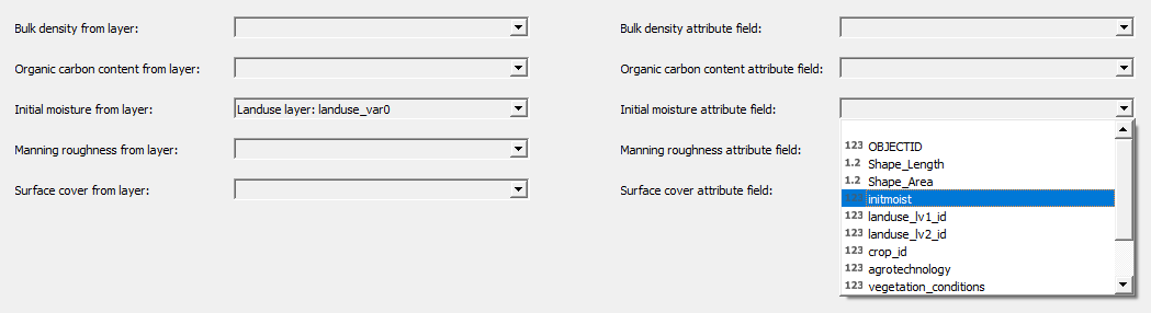
2. The KA5 class and soil identifier fields
The soil units identifier attribute field is obligatory. Each of the distinct values is used separately further on and is composed into the parametrization patch class label. The identifier can be numerical or characters, e.g. soil samples ID may be adpopted.
If the soil units were allready classified by the KA5 standard the attribute field holding the code of the KA5 class may be specified. The field is arbitrary and the classification can be done later in the process from the particle size classes content.

3. Soil units particle size distribution
In the third step the attribute fields with the 9 particle size class (according to KA5 standard) content are specified. If the soil units were allready classified but the particle size distribution is not known, then the ka5_* fields may be used instead for they hold the middle values of the grain size distribution class content for given KA5 soil class.
If only the rough grain size distribution in 3 classes (clasy, silt, sand) is known then it should be specified as the middle structural subclasses (MT = clay, MU = silt, MS = sand)

4. Landuse types classification
Type of landuse is specified by two attribute fields - the landuse itself and optionally a crop definition attribute field may be specified for the arable land. The wizard does not limit the contents and utilization of these fields. The landuse description (and crop description if provided) are incorporated into the parametrization patch class label.

5. Landuse category assignment
The attribute values from previous step are loaded into a unique values list (in combination with crop if provided) and are shown in a table. For each row the user must specify appropriate landuse category from the Catalogue. The landuse classification in the Catalogue has three levels of detail and any of the values can be used in the selection. Additional limiting conditions describing the management practices can be specified for the landuse types (management type, soil protection measures, crop and surface conditions).
By default the KA5 soil class is used for the Catalogue queries. The soil type definition detail may be reduced here. The "don't differentiate" option leads to homogenious soil properties for given landuse class.
The Catalogue query results are limited by the conditions specified. So more narrow the conditions are set the less results will be returned by the query. Not limiting some of the conditions or using more general class in the hierarchical classification of landuse or soils leads to wider set of the query results.

6. Prepared input parameters
If any of the source layers contains allready prepared input parameter values it can be used directly. For each of the input parameters a source layer and attribute field may be specified. In following steps the query on parameters that are allready prepared will be skipped leaving any missing values not present.
Those values may be manualy edited as well before the final export of the parameters table
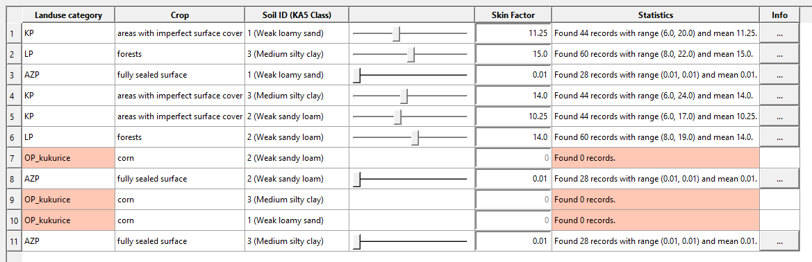
7.-12. The Catalogue query results
In following steps the Catalogue search is executed for each of the input parameters based on the conditions specified in previous steps. Interactive tables with resulting parameter values for each of the parametrization patch classes (i.e. combinations of the landuse-crop category and soil class) are provided to the user. Values for these input parameters are available in the catalogue:
- organic carbon content
- soil bulk density
- soil surface canopy cover
- hydraulic surface roughness
- soil erosion resistance
- skinfaktor
Basic statistical overview of the returned parameter value set is displayd in the results tables for each row (i.e. the parametrization patches class). The mean value of the set is used as the value parameter but it can be changed by the min-max slider or by direct input in the value field. Detailed characteristics of the value set for each row (data sources, data quality and values histogram) may be displayed by clicking the [ ... ] button in the "Info" column.
The rows with zero results of the Catalogue query are marked in orange warning the user that the detail of conditions for the row need to be reduced or the values need to be filled-in manually.

13. Optional inputs
The user can specify additional input layers that may be included into the pre-processing

DEM with channels is a modified DEM where the channels were burnt-in the original DEM. The pixels along the edges of such virtually implemented channel courses ("the banks") tend to have unnaturaly steep slopes and thus are prone to high soil erosion. A special parametrization patch class is therefor created for the channel and its banks. The original DEM specified in the first step is compared with this DEM with channels and the cells that have elevation value changed or the elevation gradient changed are included into the channel_elements class and adjusted set of input parameters can be used for them. The channel elements properties are independent of the soil units defintion
The Drain elements can be used to create special parametrization class, that is independent of the soil units definition and serves as the "perfect drain feature". As long as the initial moisture is equal to 0 (zero) all incoming surface runoff into such cell is discarded i.e. simulates the situation when the runoff is safely conducted out of the simulated area.
The Pour point feature layer is used for preparation of the observation points raster definition where the tabelated outputs are creted by Erosion-3D. A point vector layer is specified together with its integer identifier field.
14. Final review of the parameters
The complete parameters table is provided for review and edits before the final export. The particle size classes content is validated and if the sum is not equal to 100 the line is marked in red.

15. Input datasets export for Erosion-3D
Files names and destination folders are specified for the desired datasets in the last step. The user is warned if some of the values remained unfilled but the export is possible.
The DEM with burnt-in water chanels is exported if it was specified in step 13. Otherwise the non-processed DEM specified in step 1 is used for export

Reseting the wizard contents
Selected options and values (either manualy filled or found in the Catalogue) in the wizard are stored for the current instance of the QGIS software. The user can work on different projects at once and compile input parameters sets independently in multiple instances of QGIS. The wizard contents are erased when the QGIS window is closed. If the wizard is to be reset without closing the QGIS application the user can do so by clicking appropriate button and will be asked to confirm the process.
Calculating the hydraulic roughness by Garbrecht
The Garbrecht's estimate of the hydraulic surface roughness based on the particle size distribution (Garbrecht 1961) is usualy used in open channels hydraulics but with some precaution may be used also for shallow layer surface runoff. The relations don't take into account soil aggregates and are valid only for loose soils without structure (e.g. strongly smoothened surface layer after intensive rain storms)
The attribute fields of the input layer holding the particle size class' cumulative mass content are assigned to particle size classes defined by the KA5 standard. The particle size distribution is used to derive the virtual particle diameter D90, meaning 90% of the particles are smaller or equal to this diameter.

Import sediment budget result into map project
Inserting the sediment budget ("sedbudget.asc") Erosion-3D output raster into current map project speeds up the evaluation of the model results by providing the user suitable pre-defined color pallet symbology. 7 or 9 classes symbology is available both in tonnes per hectare or kilogrames per square meter. The transparency of the newly added layer can by set as well.
The selected units are used only for the visualisation and legend! Actual units of the raster layer remain unchanged (kg/m
The layer name is derived from the parent directory name of the sedbuget dataset.

Transform the pour point data for easier processing
The tool for pour point data post-processing ("pp_data.csv") transforms the records of the observatioin points for easier further processing and calculates the main runoff characteristics of the simulated event (maximum flow rate in litres per second, total runoff volume in cubic meters, total sediment mass in kilograms and overall share of clay and silt particles in sediment)
The output raster values are related to unit slope width in a single calculation step. Duration of the time-step and length of the cell edge need to be provided in order to recalculate the values to absolute units.
Resulting tables are ordered primarily by the observation point number and then by the simulation time which simplifies hydrographs and sedimentographs ploting.
